
|
| Right-side up |
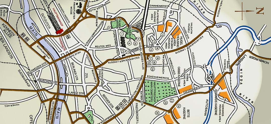
U.S. ARMY MAP OF FRANKFURT in use in the 1990's.
Compliments of the Connecticut National Guard,
which had units on TDY in Frankfurt in the 1990's.
[Above] is a center section of the Army's last known map of Greater Frankfurt before the closing of nearly all U.S. military facilities in the area in the mid 1990's. Most of the street names and landmarks were still relevant to the 1965-68 period. Drake Kaserne is on the north and Kennedy Allee is on the south, leading to the Flughafen, or airport. At the bottom of this page is a reference guide to the numbered points on the map and to other special spots. Be sure to print out a copy of this map for your next trip back to Frankfurt!
Our appreciation to Mara Hahlbrock of Berlin, Germany, for adding coloring and lighting effects to the original, drab, black & white map. Mara is the sister of PIO staffer Paul Leopold.
GUIDE TO ABOVE NUMBERED POINTS
7. Abrams Bldg. (IG Farben)
8. FKT American High School
9. Terrace Club
10. Idle Hour Theater
11. Civilian Personnel Office
12. Carl Schurz Housing
13. FKT American Ele. School
14. FKT Community HQ
15. FKT Housing Office 16. Commissary
17. Main PX
18. Topper Club (NCO)
19. PX Gas Station/Garage
20. Armed Forces Network
22. 97th General Hospital
23. 97th Officer's Club
24. Plantation Club
25. Motor Pool No. 1